
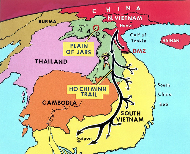
The military historian Jacques C. Despuech once remarked, “The entire Ho Chi Minh Trail that people talk about today is the culmination of centuries of struggle and oppression; the trail’s vitality diminishes not because it is a mere path, but because it symbolizes the fight of an entire nation.” Let’s explore the Ho Chi Minh Trail Map.
More than 60 years ago, a historic milestone in the nation’s history was marked by a network of routes collectively known as the “Ho Chi Minh Trail” (comprising five routes: the Ho Chi Minh Trail on land (Truong Son Trail), the Trail on the sea, the Oil Pipeline Trail, the Air Route, and the Money Transfer Route). This strategic military transportation network was crucial in transporting troops, supplies, and weapons from the North to support the battlefront in the South. Along these routes, tens of thousands of officers, soldiers, youth volunteers, and civilian laborers resiliently clung to the forests and roads, contributing to remarkable military successes.

It should also be noted that the history of the formation of these trails dates back to before the Vietnam War, but they only evolved into a complex network during the course of the conflict. In the past, when discussing the logistical support from the North to the battlefront in the South, the focus was primarily on the Truong Son Trail. Approximately one million tons of U.S. bombs wreaked havoc along the Truong Son Trail, causing the loss of around twenty thousand soldiers from the North and leaving another 20,000 individuals disabled. Despite playing a significant role in supplying the South and maintaining communication between the two regions, other supporting routes did not garner much attention. This was mainly because they were kept secret by those directly involved, the local population, and foreign individuals who held a deep affection for Vietnam.

Truong Son Trail
As mentioned earlier, the trails on the Truong Son Range have a long history, dating back to feudal times and the resistance against the French colonialists. After the Geneva Agreement in 1954, these trails became desolate, leaving only secret communication lines for correspondence, based on the contacts of ethnic minorities on the eastern side of the Truong Son Range. In early May 1959, following the 15th Central Committee Meeting in North Vietnam, with the direction to intensify armed struggle to liberate the South, North Vietnam planned to organize a special military transportation convoy to deliver personnel, weapons, and goods to support the South.
After two years of transportation, by 1961, following the period of the Dong Khoi Movement, the demand for support to the South escalated significantly. The United States also took notice of this trail and intensified their search and sweep operations. Consequently, North Vietnam opened another route in Laos, transforming it from a single path into a comprehensive network.

After the Paris Peace Accords in 1973, the U.S. ceased bombing, and the trail rapidly expanded in terms of coverage and scale. During the Spring 1975 General Offensive, the trail ensured swift mobility for three divisions, five regiments, and two logistical battalions, serving the movement of 411 thousand individuals (including civilians) across various battlefields.
Ho Chi Minh trail on the sea
The route was officially established on October 23, 1961, to transport additional human resources and weapons from North Vietnam to support the Southern Liberation Army during the Vietnam War. In the initial period, the convoy consisted of small-sized transport ships designed to infiltrate the South. Although these ships had full registration numbers, to maintain secrecy, they did not paint the numbers on the hulls. Hence, these ships became collectively known as the “Unnumbered Ships.”

The shipping figure announced by the Ministry of Transport in the book “History of Transport” combined over time is 44,324 tons.
The number of tens of thousands of tons traveling by sea is much smaller compared to the number transported by Truong Son route. But its significance is very great. The above tens of thousands of tons had a vital meaning for hundreds of divisions in bases in the southern coastal region. On the other hand, the sea transport route, although causing large losses, has advantages over the road in that it has a low cost per volume and very high speed, helping to create surprise and combat superiority. These include medical equipment, specialized machinery, and chemicals for making explosives.


In addition to the special goods mentioned above, there is another extremely important “good” which is key officials and special experts in charge of the most important fields in the South.


Oil Pipeline Trail in Ho Chi Minh Trail Map
This is also a legendary road that Americans have never known or only know very vaguely. The reason they didn’t know about it was because they couldn’t imagine that under Vietnam’s technical conditions, being bombarded by air force continuously at any coordinate could still form a gasoline pipeline. The oil is thousands of kilometers long, from the Vietnam-China border all the way to the South, and is also connected to many small ports to receive oil from ships…

Since 1968, due to increased fuel requirements, long-distance transportation of gasoline by car has become both vulnerable to raids and very expensive. If transported over a short distance of a few hundred kilometers, it is still effective, but if transported over a distance of thousands of kilometers, the fuel consumption for the vehicle itself accounts for up to 1/3 of the fuel transported on the vehicle. Not to mention the huge losses due to air bombardment.
Furthermore, when transporting hundreds of thousands of tons, there is always a shortage of drums. Therefore, on April 12, 1968, a unit called Irrigation Construction Site 01 was born, initially consisting of only 34 soldiers who were intensively trained in pipe installation techniques. Pipeline construction was really difficult with the technology of that time.


As of the spring of 1975, after 7 years of construction and development, the petroleum pipeline system had a total pipeline length of more than 5,000 km, 114 pumping stations, more than 100 petroleum depots, and the capacity contains over 300,000 m3. The petroleum army has developed into 9 pipeline regiments, 2 construction regiments, 1 information regiment, 2 mechanical factories, 3 truck battalions, and has provided 5.5 million m3 of gasoline for the Southern.
Ho Chi Minh Trail in the air
There are two air transportation routes: the military route and the civilian route. Concerning the military route, to facilitate the urgent transport of heavy goods, the Vietnam Air Force established a special transport unit called Unit 919. Since 1960, Unit 919 has been responsible for transporting a section of the Truong Son Trail, aiming to reduce transport time and alleviate a lengthy road section spanning thousands of kilometers from the North to the South.


From 1960 to 1962, on the Laotian battlefield, aircraft from Squadron 919, in coordination with Soviet pilots, conducted 3,821 flights, transporting 9,419 military personnel and 743 tons of cargo. They also airdropped 3,227 parachute troops and cargo into 20 different locations across Laotian territory.
However, the air transportation route through Laos only existed until the dissolution of the Tri-Partite Coalition Government in Laos in 1963. Starting in 1965, due to the U.S. aerial bombardment in the North, it became impractical to use cargo planes to transport goods to Quang Binh or cross over the Western Truong Son Range. It wasn’t until the beginning of 1973, after the signing of the Paris Peace Accords on Vietnam, and the establishment of legal liberated areas in the South, that the new form of military air transportation became widely utilized once again.
Even more surprising is the form of civilian air transportation. Civilian air transportation is a method that operates “openly but secretly.” This is the regular civilian air transportation route of the Kingdom of Cambodia (Air Cambodia), flying from Phnom Penh to Hanoi or from Phnom Penh to Guangzhou, Hong Kong, then continuing by rail or air to Hanoi. This route is considered very secure as it involves a legal and openly conducted risk.

Money armies and money transfer routes
Throughout the 20 years of the resistance against the United States, there was an exceptionally secretive currency transportation route operated flexibly and innovatively by a heroic trio from the banking sector. This involved the Special Foreign Exchange Fund (B.29) in Hanoi; the Special Financial Committee (N.2683) and the Credit Committee (R-C32) in the South.
In the early years, the source of international aid in foreign currency was quite limited. The Central Budget had to allocate funds to purchase Saigon currency (Z money) in foreign markets, and then transport it to the South by road. However, starting from 1960, the United States escalated aerial warfare in the North. Since then, bringing financial aid and materials into the South faced numerous difficulties and risks.

In 1965, B.29 was established to mobilize foreign currency from both domestic and international sources, converting it into currencies such as the U.S. dollar, Thai baht, and Laotian kip. In the Central Bureau of the South, there were two units directly responsible for receiving money and converting it from U.S. dollars to other currencies: N.2683 and R-C32.
Initially, the primary form of transportation was hand-carried (referred to as AM). Later, a new money transfer method (referred to as FM) was developed by utilizing businesses affiliated with N.2683, nominally engaged in production and business, to withdraw Z money. Subsequently, B.29 would transfer U.S. dollars back to them through accounts abroad.


After the liberation in 1975, B.29 settled its accounts and returned the remaining amount, approximately 220 million dollars, to the government.
| Remaining balance of the Special Reserve Fund managed by B.29 until the end of 1975 | $149.431.767,38 USD |
| Foreign exchange reserve from various battlefields turned in (B.2 and K.5) | $53.803.361 USD |
| General Logistics Department of the military handed over | $508.673,29 USD |
| B.29 continued to manage and operate the Special Fund, earning interest on deposits abroad and deposits at the Foreign Trade Bank of Vietnam | $14.730.374,94 USD |
| Total | $218.474.176,61 USD |
Conclusion
After presenting the five different routes that the North established to support the South, you may have two misunderstandings, along with two questions:
- Firstly, are the efforts and successes of these routes a result of the organizational skills, patriotism, determination, self-sacrifice, intelligence, and bravery of the revolutionary soldiers of North Vietnam? On the other hand, could it be due to the naivety or incompetence of the opposing side?
- Secondly, it appears that only the North was capable of infiltrating the South, while the South had to passively defend, resist, and cope. Is this due to the overwhelming pressure from the invading routes from the North, making it impossible to withstand? Is the border, both on land and at sea, too lengthy and treacherous for effective resistance?
Regarding the first question, it cannot be denied that the North Vietnamese army may have been inferior in many aspects, but unquestionably excelled in terms of determination. However, on the Vietnam battlefield, during the Vietnam War, and at any time, there has always been another crucial factor with decisive significance: THE PEOPLE. This war is the war of the entire people.

Regarding the second question: Did the South have a policy of invading the North, and did they implement that policy in reality? I would like to say: Yes! There was indeed a policy, even a national strategy, and a very high level of determination.
From 1955 to 1959, the North maintained a policy of preserving peace and unity through organized elections, which was an order. However, this policy was revoked in 1959 when the government of Ngo Dinh Diem issued the Law No. 10/59, carrying out brutal massacres against communist bases. Since 1956, President Ngo Dinh Diem had adopted the slogans “Go North” and “Fill the Ben Hai River.” Even during the time of President Nguyen Van Thieu, the government of the Republic of Vietnam persisted in that slogan. The efforts of the United States and South Vietnam were often ineffective, because they did not have the support of THE PEOPLE, also.

References
- 5 con đường mòn Hồ Chí Minh, Đặng Phong
- CHÂN TRẦN, CHÍ THÉP, James G. Zumwalt
- Đường Trường Sơn
- Đường_Hồ_Chí_Minh_trên_biển
- Documents on the .gov.vn pages of the Vietnamese government